Civil Parish
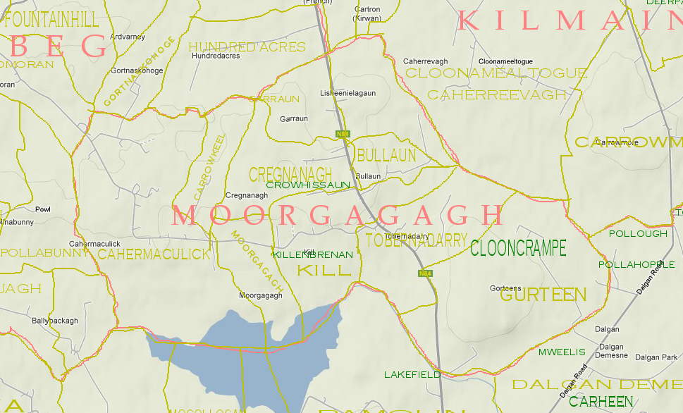
Moorgagagh
Moorgagagh
Civil Parish : Moorgagagh.County : Mayo
Poor Law Union : Ballinrobe
Barony : Kilmaine
O.S. Maps : Mayo - 121 . 122
R.C. Parish : Kilmaine
R.C. Diocese : Tuam
R.C. Church : Kilmaine
Marriage Records : 1854
Baptism records : 1854
Official O.S. townlands
Townland names in this parish officially recognised since Griffiths ValuationPlacenames :: unofficial
Known locations other than official townlands where the geographical location is known.Placenames whose locations are unknown
(B&M) :: Mentioned in the parish baptism and marriage records but locations unknown.(PA) :: Places mentioned in The Survey and Distribution book and Petty's Atlas(1641..1703).
(TA) :: Places mentioned in The Tithe Applotment book (1825-35).
- None yet (B&M)
- None yet (PA)
- None yet (TA)
Archealogical ,Geographical and Islands.
(A) :: Archealogical features associated with the parish(G) :: Geographical features in this parish.
(I) :: Islands off shore from this parish.
- None yet (A)
- None yet (G)
- None yet (I)
The Tithe Applotments
Information from the Tithe Applotments circa 1825
| Tenants Name | Placename | Miscellanious Notes |
| Michael Hughes | Bullaun | |
| Charles Hemry Cromie | Cahermaculick | C.H.Cromie Esq. |
| John Kilkelly | Cahermaculick | |
| John Shaughnessy | Cregnanaugh | J Shaughnessy Esq. |
| Pat Kine | Gurrane | |
| Thomas Meagh | Gurteen | |
| James Carrick | Gurteen | |
| Martin Rowland | Gurteen | |
| John Shaughnessy | Kille | |
| Laurence Murphy | Crowhissane | |
| ? Darcy | Crowhissane | |
| Henry Burke | Crowhissane | |
| Pat Casey | Lisheeneelagaun | |
| John Burke | Lisheeneelagaun | |
| William Brannick | Moorgaga | |
| John Shaughnessy | Tubbernadarree | |
| William Blye | Tubbernadarree | |
| William Rily | Tubbernadarree |
Lewis's Topographical Dictionary 1837.
The Moorgagagh entry in Lewis Topographical Dictionary of 1837MOORGAGA
Lewis' Topographical Dictionary (1837)A parish, in the barony of KILMAINE, county of MAYO, and province Of CONNAUGHT,5 1/5 miles (N.) from Headfort, on the road to Ballinrobe; containing 518 inhabitants. The parish comprises 1362 statute acres of arable and pasture land. It is a rectory and vicarage, in the diocese of Tuam, forming part of the union of Kilmainmore : the tithes amount to �55. In the R. C. divisions it is part of the union or district of Kilmain.
There is a private school, in which are about 160 children. From the fine ruins of the abbey of Kill, part of the possessions of the Benedictines in the 12th ,century, situated near the border of a small lake, an extensive and interesting view is obtained.
Field Name books from 1840's
Field Name Book description from 1838/1839 noted by the surveyors who produced the O.S maps originally.PARISH OF MOORGAGAGH
Moregaga.Parish
B.S.S.M. :: Mór Gágach, split or chinked wall or house.- Moorgagagh : J. 0'D,
- Moregagagh : County Book
- Moorgagagh : Tithe Ledger
This name is said locally to be the original name of the old church, which stands in ruins in Moorgagagh td., and which is said to have obtained the epithet Gagach from having its walls split by the heat of the sun. The word Mór, which is cognate with the Latin Murus, signifying a wall, was used by the ancient Irish to signify, not alone a wall, but a house or castle. For example, Mur Ollamhan, the House of the Ollavs, at Tara, and Mur na mBrathar, the douse of the Friars, at Donegal. This parish is situated in the east side of the barony of Kilmaine.
It is bounded on the N. by the parishes of Kilmainemore and Kilmainebeg; W. by the ph. of Kilmainebeg; S. by Shrule parish; and E. by the phs. of Shrule and Kilmainemore. It contains 1,789a. 1r. 5p., statute measure, of which 86a. Or. 4p. are water. It is a rectory and vicarage in the diocese of Tuam, and its tithes amount to £55. In the td. of Kill are the remains of an old abbey.
Miscellaneous Features
Lough Kill
B.S.S.M. 12Loch na Cille, the lake of the church.
- Loughnakill: J. 0'D,
Situated on the southern boundary of the parish, and on the northern boundary of Shrule parish. This lake is almost dry in the summer season.
Lough Lee
B.S.S.M. 13Loch Laoigh, lake of the calf.
- Lough Lee : J. 0'D,
- Lough Lee : County Book,
- Lough Lee : Local
This lake is situated on the southern boundary of the parish and of the td. of Gorteens.
When searching for a placename type some or all of the word and click search. If you are unsure of the spelling try a part of the word . For example the placename Mocharra sounds like Moharra so if you search for arra you should find it. For example a placename record ( eg Rostaff ) gives the townland ( eg Moyne ) and the civil parish ( eg Shrule ) .