Shrule Town
Official Townland name

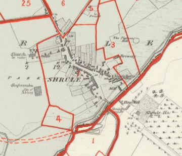
Click on map for a more detailed version

Click on Town Plan for a more detailed version
Click on the Griffiths Valuation Ballinrobe Page # 152 to see a list of tenants with plot numbers to match the Griffith map.
Placenames
Placenames mentioned in this townland are :Field Name Book
Field Name Book description from 1838/1839 noted by the surveyors who produced the O.S maps originally.Shrule Town
B.S.S.M. : 27See parish name.
- Shrule : J. 0'D,
- Shroule : Down Survey Maps
Situated in the South of the parish. It is bounded on the N. by Ramolin td.; W. by Cloonbanaun td.; S. by the parish of Donaghpatrick in County Galway; and E. by Dalgan Demesne.
The village contains 86 houses; .many of which are neatly built, and the salubrity of the climate is such as to render it a desirable residence for invalids.To the rear of Riverview is a hamlet called Gurtloygraph in which are manyinstances of longevity. An extensive brewery is carried on, and there are large corn-mills, the property of R. Golden, Esq. A market for corn is held here every Thursday, which is abundantly supplied and there are fairs on Easter-Monday, July 26th, and Nov 11th. A constabulary police force is stationed in the village and petty sessions are held on alternate Thursdays.
There are in the village 9 public houses and a police station, together with a police station and a brewery. The latter has been built, and is occupied, by Wm. Golden, Esq., who holds it under a lease of 999 years at a rent of £30 per annum.
The antiquities here are an old castle, an old fort, an old church, and the site of an old abbey. Near the N.E. corner of the latter is a large stone called Cruckvahina, or the Blessed Stone. (Clock Bheannuighthe, the blessed stone).
When searching for a placename type some or all of the word and click search. If you are unsure of the spelling try a part of the word . For example the placename Mocharra sounds like Moharra so if you search for arra you should find it. For example a placename record ( eg Rostaff ) gives the townland ( eg Moyne ) and the civil parish ( eg Shrule ) .
